
Richmond Previous Resident Sources
Richmond address history crosses several eras. The Madison County Clerk's genealogy holdings reach back to the county's first years, while the present parcel viewer supplies the key needed to enter that older trail. Maps and published lists fill the years between. The table separates title evidence from household clues so an owner is not casually labeled an occupant.
| Source | Years It Covers | Where Held | What It Shows |
|---|---|---|---|
| County deed books | 1786 to present | Madison County Clerk | Grantor, grantee, legal description, and prior deed references |
| County plats | 1800 to present | Madison County Clerk | Lots, blocks, subdivisions, and boundaries |
| Commissioners deeds | 1791 to 1979 | EKU Digital Collections | Scanned commissioner and heir instruments in an incomplete series |
| Sanborn map | November 1886 | Library of Congress | Street names, footprints, and building uses on three sheets |
| Federal census | 1790 to 1950 | National Archives and library databases | Households, relationships, streets, and enumeration districts |
| Southern Bell directory | March 14, 1966 | Lexington Public Library digital collection | Subscriber, address, telephone, and business snapshot |
| Current parcel map | Current; online start not published | Madison County PVA and GIS | PIN, situs, tax year, geometry, and assessment context |
Start with the source nearest the target date. For a recent Richmond property, use the current parcel and its deed reference. For a mid-century household, begin with the dated directory or released census and then confirm the parcel through deeds. An eighteenth- or nineteenth-century inquiry may not have a familiar street number at all. It must follow a legal description, plat, landmark, or mapped footprint. The current viewer is a locator, not a full account of previous residents.
A Richmond Parcel Starts the Trail
The Madison parcel and address viewer accepts a parcel number, PIN, property address, or subdivision. Its result grid identifies the PIN, tax year, and property address. Save those fields before opening other records. The PIN helps distinguish two similar street numbers, a corner lot, or land that was later split.
The PVA describes its free basic search as an ownership and assessed-value tool. Subscription material may add transfer history, sales dates, photos, improvement facts, property class, and tax information. None of those fields proves who slept at the site. The owner's mailing address may also differ from the situs, meaning the physical property address. Keep owner, mailing, tax-bill, and situs fields separate.
Use map geometry to spot the lot's edges and adjoining PINs. If an old address seems missing, check for a split, consolidation, road rename, annexation, or unit change. A current street label should never erase the wording found in an older deed.
Richmond Owners in the Deed Chain
The Madison County Clerk Recording Department keeps deeds, mortgages, plats, wills, court orders, and other filed instruments. Its historical list says deeds run from 1786 to the present and plats from 1800. The web route is eCCLIX, which requires account access for its live land-record index and images. When that barrier blocks a search, call or visit the clerk at 321 N Madison Avenue rather than guessing at a missing deed.
- Copy the current PIN, owner field, legal description, and deed book or instrument reference from the parcel record.
- Find the present owner's purchase deed. Record both parties, the instrument and recording dates, and every prior book and page citation.
- Search the seller as a grantee to find that party's earlier purchase. Test spelling variants and roles such as heir, estate, trustee, commissioner, or sheriff.
- Repeat the link backward. Follow the legal description when the street number changes, and mark every gap rather than forcing two parcels together.
- For material unavailable through eCCLIX, use the clerk's books or request route and ask what identifier is needed for a copy.
- Grantor and grantee
- The grantor transfers an interest; the grantee receives it.
- Chain of title
- The linked series of instruments that traces ownership through time.
- Legal description
- The land wording, lot and block, plat reference, or measured boundary that identifies property more reliably than an old street number.
The Kentucky deed research guide advises searching both grantor and grantee indexes. It also explains special index marks for heirs, commissioners, and sheriffs. Those roles often signal inheritance, a court-ordered transfer, or a sale outside an ordinary purchase.
The official eCCLIX login route shows where online Madison County index access begins.
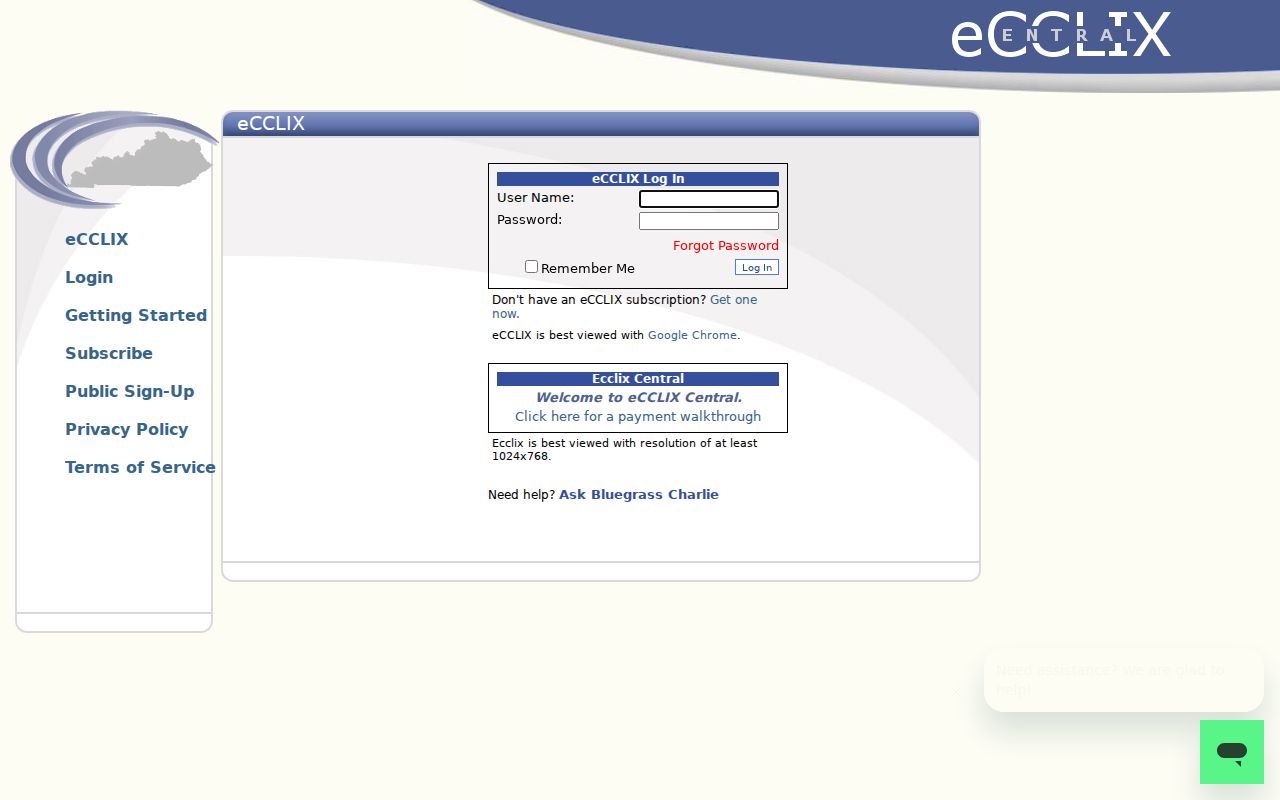
The captured screen also explains why a login barrier is not a negative record result. Use the clerk counter or request path when the live index cannot be inspected.
Richmond Deeds Beyond eCCLIX
Eastern Kentucky University provides a useful image route when the paid index is not enough. Its Madison County Commissioners Deeds Series contains 784 scanned items dated from 1791 through 1979. The collection is incomplete, so a failed digital search does not mean the county lacks an instrument. It is best treated as a window into the deed form and language.
A commissioner may convey property after a court action, estate matter, or other ordered process. A widow's dower, an heir, a sheriff, or an estate can also interrupt an easy seller-to-buyer chain. When one appears, move sideways into Madison wills, court orders, dower allotments, probate files, and delinquent-tax material. Then return to the land description and the next recorded deed.
The image and the index serve different purposes. An index points toward a book or instrument. The image contains the terms, relationships, dates, and description that can prove whether the Richmond parcel is the right one.
Richmond's 1886 Address Bridge
Modern parcel numbers did not exist in the nineteenth century. The November 1886 Richmond Sanborn map offers three sheets of street, building-footprint, and use detail. It can place a structure near a cross street and show how a block was arranged. It does not name the owner or every person who lived there.
Use the map as a geographic bridge: compare the old street and footprint with a recorded plat, deed boundaries, and the current GIS geometry. If the pieces disagree, preserve the conflict. The number may have changed, the lot may have been divided, or the historic structure may no longer exist. A legal description and cross street are stronger fixed points than a matching number alone.
This geographic method is especially useful for previous residents whose records predate standardized addresses. It also prevents a later Richmond postal label from being mistaken for proof that an old parcel lay within the same city boundary.
Previous Richmond Residents in 1966
The digitized Southern Bell telephone directory dated March 14, 1966 is a rare exact snapshot. Its 70 pages cover Richmond along with Ford, Kirksville, Waco, Berea, Paint Lick, and nearby communities. A subscriber and address can lead to a past household, but publication was not compulsory and does not list all residents.
Record the publisher, date, page, original spelling, and whether the entry is a person, business, or institution. Then test the address against a parcel, deed, obituary, newspaper, or census source. The broader geographic coverage matters. A Richmond-area listing may describe a postal or exchange area rather than the incorporated city.
For the collection itself and methods for reading abbreviations, use the Richmond Directory Book. The task here is narrower: connect one address to a dated name without turning a telephone subscription into permanent residency.
Pair Richmond Directories and Census
Federal schedules supply a household layer that deeds cannot. The National Archives covers census records from 1790 through 1950, the latest released population schedule under the 72-year rule. A census can show household members, ages, relationships, and street or enumeration-district context. OCR and street indexing remain imperfect, so view the original page.
- Choose a dated directory or newspaper address near a released census year.
- Search the named subscriber, then try relatives and spelling variants if the first query fails.
- Use the street, cross street, and enumeration district to inspect nearby schedule lines.
- Compare household names with the deed owner and cemetery, probate, or obituary evidence.
- Label each conclusion by year and source. Do not carry a 1950 household into 1966 without new proof.
An enumeration district is the area assigned to one census taker. Its map or description can recover a Richmond block when a name search or old street number fails.
Richmond Records Before Street Numbers
Madison County was formed in 1785, and Richmond became the county seat in 1798. That history explains why deed, marriage, will, and court-order holdings begin in 1786, well before present address systems. A person tied to early Richmond may appear through a county land or probate act rather than a town directory.
Plats begin in 1800, while fiscal-court orders begin in 1897. Use the right book family. Early deeds can point to waterways, adjoining owners, roads, or measured bounds instead of a house number. Later records may cite the same tract by lot and plat. The clerk's Richmond counter is the fallback when no searchable image or continuous city-directory run is online.
Note: A county-seat record can concern land elsewhere in Madison County, so confirm the legal description before calling it a Richmond address.
Confirm Richmond's Past Households
Owners form only half of an address history. A relative, boarder, or other occupant may never appear in a deed. The Madison County Public Library genealogy resources connect researchers with obituary and newspaper databases, Ancestry Library Edition, marriage indexes, and local cemetery material. Library staff also offer one-on-one genealogy help that can turn a vague street problem into a source plan.
An obituary may name relatives, a church, a cemetery, and former places. Probate can link heirs to a parcel after an owner's death. Richmond Cemetery's A-Z and Veterans index adds a burial-location code, though burial alone does not prove residence. Search each as a lead, then confirm it in the record image or with the custodian.
A sound final timeline uses cautious labels: title owner, assessed owner, subscriber, census household member, obituary address, or inferred match. It also records the search date and the missing years. That makes the answer useful even when the chain of previous residents is not complete.
Lawful use. Richmond address research supports house history, genealogy, and personal curiosity. Kentucky stalking and harassment laws still apply, so never use a record to track, threaten, or disturb a living person.